Physical space in a MySpace era: Do the locations of our friends matter?

Physical space in a MySpace era: Do the locations of our friends matter?
- November 17, 2008
- Researchers awarded grant from NSF to study impact of geography on social networks; findings will help them understand how physical space and closeness contribute to perceived feelings of safety and cohesiveness among neighbors based on where their networks exist - information useful to urban planners interested in developing and shaping communities to fit residents' social and interpersonal needs
-----
 Between cell phones, email and online social networks, keeping in touch with friends
and family has never been easier, whether you're only five or 5,000 miles apart. As
we become ever-more reliant on technology for staying connected, do where our contacts
live still matter?
"Despite the power of information technology to keep us connected across long distances,
geography still plays a role in shaping our social relationships," says UCI sociologist
Carter Butts. "Location and spatial structure affect our opportunities to interact
with others, our perceptions of the neighborhoods in which we live, and how we share
information during emergencies."
With a newly awarded $750,000 National Science Foundation grant, Butts is leading
a research team to discover just how much our social networks are impacted by geographic
and spatial structure as well as socioeconomic status. Working with him are John Hipp,
UCI criminologist, and Nicholas Nagle, University of Colorado geographer. Findings
from their study will have wider applications for urban planning and models of communication
during crisis situations.
Over the course of the three year study, the researchers will conduct a large scale
survey throughout Southern California to find out who residents contact most, how
well they feel they know their neighbors, who they call when emergencies happen, and
where those contacts are located. They will then pair the information with census
data to determine how interconnected people within neighborhoods are and how far out
- geographically - those connections go.
Findings from the survey and social network models derived from the results will help
researchers understand how physical space and closeness contribute to perceived feelings
of safety and cohesiveness among neighbors based on where their networks exist - information
they say will be useful to urban planners interested in developing and shaping communities
to fit residents' social and interpersonal needs.
Their findings will also be helpful for first responders in the development of future
information dissemination and emergency warning systems by suggesting the best places
to inject messages into residents' social networks.
"When emergencies happen, getting information out to the largest number of people
in the shortest amount of time is a critical but often difficult task," says Butts,
who has studied the topic at length as part of UCI's on-going Calit2 Project RESCUE study. "Knowing where to find the key contacts for reaching the most members of a
given community can be extremely useful in developing more focused, effective crisis
communication plans."
After mapping out the relationship networks of Southern Californians, the research
team plans to expand the project nationwide in order to learn more about the impact
geography plays on our social connections to others and how such information may be
applied to keeping more people "in the know".
The three year NSF study began in October and will continue through September 2011.
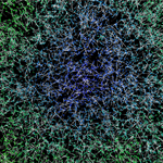
Pictured at right: A social network model based on information collected in a prior
study for an area the size of Phoenix. The model shows how information would be expected
to pass following an emergency with blue representing those who receive information
first. The colors shade into green and yellow for those who take longer to receive
it.
-----
Would you like to get more involved with the social sciences? Email us at communications@socsci.uci.edu to connect.
Share on:
Related News Items
- Careet RightNotes from a future professor
- Careet RightCan Opportunity Zones ever meet their poverty-fighting promise?
- Careet RightFei Yuan named one of ten global China Times Young Scholar Fellows
- Careet Right'Wired for Words: The Neural Architecture of Language,' an excerpt
- Careet RightEveryone's looking for a partner who has these 3 traits, according to research


